"Call a person a "futurist," and everybody crowds around to hear a tale of doom – and maybe what we can do to avoid it. Call a person a "hippie," and everybody runs for cover.
I think the difference really is in the language each uses. When someone talks about thinking seven generations, or 20 generations, or 100 generations into the future with our decisions about energy consumption and food consumption, that person is a hippie, and therefore crazy. When someone talks about running out of food and oil in 300 years, and describes what the world will look like if we don't start doing x, y, and z, that person is a futurist, and therefore a visionary." - The Alchemical Nursery
Tuesday, May 31, 2011
Climate ch-ch-ch-ch-changes

In my previous blog, I sought inspiration from one of my childhood heroes, the original space oddity, David Bowie, as I sought to focus on just a few of the millions of climate changes happening throughout our world as we deliberately and permanently alter a planet on which we (geologically) just arrived, moments ago. In my imagining, the man who fell to earth invites us to consider the rather insane changes we are unleashing haphazardly and blindly on a world that existed quite happily without us for over 4 billion years and likely looks forward to doing so again. According to Earthweek, we now have more evidence that "far more serious consequences to climate change could be in Earth's future than just warmer temperatures" as "melting sea ice in the Arctic Ocean is making it easier for toxic chemicals stored in the polar region to escape into the air."
And "global warming could cause changes in the water cycle that threaten to alter stream acidity worldwide." And "an unprecedented number of forest fires are likely to occur around the planet unless global warming is not curbed through significant reduction in carbon emissions in the near future." And "global warming is also pushing ocean temperatures to record highs, causing extensive coral reef damage. Further damage as the oceans warm even more could destroy the marine food chain."
Sing it with me now: Ch-ch-ch-ch-Changes
Turn and face the strange
(Ch-ch-Changes) Read More
Physicist Axel Kleidon Says Wind and Wave Energy Not Renewable, Could Adversely Affect Environment In a provocative paper to be published in the Philosophical Transactions of the Royal Society, German Physicist Axel Kleidon says that there is a limit to the amount of energy humans can extract from wind and wave power, and that in using these sources we could affect our environment in ways as serious as the greenhouse effect. Put simply, Kleidon’s argument is that there is only a finite amount of wind available on the earth, and the attempts humans made to exploit that wind for energy useage in wind turbines actually affect wind patterns and thus the amount available wind to harness for energy use. According to his theory, the more wind farms we build will lead to more turbulence, changes in precipitation and cause atmospheric changes which could change the amount of radiation reaching earth’s surface...
Environmental hazards remain after Joplin tornado As residents confront a gigantic cleanup following the tornado that savaged Joplin, experts say environmental dangers could lurk amid the mountains of debris in the southwestern Missouri city and even in the water and air. Damage from tornadoes, like floods and hurricanes, often goes beyond what is readily visible. Liquid fuels and chemicals can leak from ruptured containers and contaminate groundwater. Ruined buildings may contain asbestos. Fires can generate smoke containing soot, dioxins and other pollutants. Household, industrial and medical wastes are strewn about...
Wednesday, May 25, 2011
World in collision with mass extinction?
"...overfishing of our oceans and depleting fish stocks to dangerous low levels; ...toxins, emissions and pollution...making the hole in the ozone layer bigger and causing more harmful sunrays to penetrate...thus warming the oceans, melting the ice, and threatening animal's environments; ...rainforest being bulldozed...to create grazing land for cattle and commercial development, thus destroying natural environmental structure and animals habitats...animal species going extinct, and more."
Earth Changes Map Progressions with Lori Toye of I AM America
This segment from Paranormal Borderline discloses the prophesied progression of Earth Changes events of the I AM America Map: the I AM America 6-Map Scenario Map. Safe areas of the I AM America Map are revealed. Lori places spiritual emphasis on personal choice and global consciousness; and their innate ability to alter or ameliorate cataclysmic predictions and create a positive outcome for earth's future generations.
Biggest Floods in History—Does Mississippi Make the List?

for National Geographic News
This story is part of a special National Geographic News series on global water issues.
As the crest of the Mississippi River flood moves through New Orleans and out to sea this week, peak river levels recorded during the month-long deluge threaten to top even the Great Mississippi Flood of 1927.
The most destructive river flood in U.S. history, the 1927 event moved about 2 million cubic feet (65,000 cubic meters) of water—enough to fill about 26 Olympic-size swimming pools—every second. (See pictures: "Mississippi River at Its Worst.")
"The numbers are still provisional, but [the current flood's peak water discharge] looks to be about the same" as the 1927 flood, said James O'Connor, a hydrologist with the U.S. Geological Survey (USGS).
Still, the 1927 and 2011 Mississippi River floods remain just drops in the bucket compared to other known freshwater "megafloods" around the world, according to O'Connor.
The scientist co-authored a 2004 USGS report that ranked all freshwater floods known to have occurred during the past two million years. The list, which remains largely unchanged since its release, includes only floods that had peak discharges of 3.5 million cubic feet (100,000 cubic meters) a second or more.
Ice-Age Deluge
As of 2010, the number one flood on the USGS list swept through what are now Oregon and WasState (map) about 25,000 to 15,000 years ago, during the last ice age. Read More
Thursday, May 19, 2011
Blue Marble in the year 3000
Ever since Frank put together the "Blue Marble" overlay, it's been one of my favorite overlays for Google Earth. I leave it on almost all the time, because it creates such a nice view of the earth when seen from very high altitudes. Of course, the Blue Marble only shows how the Earth looks right now. What if you could see the past (and future) of our planet with a similar overlay? That's what the folks at ZHAW have put together, and it's quite impressive. They've created a few animations that show changes in the Earth's glaciers, vegetation and sea levels throughout the years. Here's a look at their "Blue Marble 3000" animation, which begins 21,000 years ago, and ends in the year 3000.
They also have a version of it that starts with present-day Earth and goes until the year 10,000:
In addition to the views, they've created overlays that you can use inside of Google Earth. You can find more info about Blue Marble 3000 here, and Blue Marble 10,000 here.
They collected the data from a variety of sources, and certainly had to make some estimations for future ice and shorelines. Still, it's an interesting look at where we've been and where we might be heading.
Extreme makeover: are humans reshaping Earth? If alien geologists were to visit our planet 10 million years from now, would they discern a distinct human fingerprint in Earth's accumulating layers of rock and sediment?...

(Right) Cynthia Hart-Button figures the birth of so many white buffalo "means there are earth changes coming." This is among three white buffalo calves born over the Mother's Day weekend at Hart-Button's sanctuary near Bend.
What may be the world's biggest herd of white buffalo has just gotten bigger. Three white bison calves were born on a 288-acre sanctuary near Bend over the Mother's Day weekend, bringing the number of white bison to 14...
Sunday, May 15, 2011
Saturday, May 14, 2011
Weather, Vortices and the Pole Shift
I was just reading through the Arlington Institute site to investigate one of their programs called Weather Map, which collates our collective intuitive and dream experiences to glimpse into future trends. This was part of my research regarding my last blog Sightings, Dreams and Chevrons.
One link that caught my eye was the following: ‘A growing number of scientists suspect that the magnetic pole shift that seems to be underway may be the real culprit behind climate change.’
This reminded me of a very recent meditation in which I was ‘shown’ the dynamics behind the recent tornadoes in the South and Southwestern parts of the U.S. – anomalous to be sure.
I set my intention on understanding the nature of these extreme weather anomalies. As I relaxed, images began forming. I was first shown that the Gulf Stream was no longer running as it had in the past and that this is linked with electro-magnetic vortices creating geo-magnetic change. This led me to a rather shocking article I researched after the meditation, which I will speak of later in this blog.
Next was the main part of the vision in which I had a birds eye view over the South of the U.S. Below me was a vortex of energy flowing counter-clockwise, which was its normal directional flow. Suddenly a counter-rotational vortex appeared alongside it, moving clockwise. Where the two forces met there was a disturbance, presumably the tornadoes I had asked about. This friction, where a new field of polarity was attempting to establish itself in the place of the old, was shown to be the source of all types of geological and meteorological disturbances. In addition, it was shown that this type of phenomena would become much more common in the times ahead until the new polarities were successfully established. In other words, there would be one mini pole shift after another around the planet.
Finally, there was a brief image of the sun and powerful sun activity, which was also a part of this unfolding dynamic that is now firmly in play. The summary was that this is now the norm and necessary as the earth goes through this polarity shift, which is accompanying a dimensional shift that has long been spoken of.
Meanwhile, I came across an article some of you may be familiar with regarding a vortex formation in the Gulf of Aden. The author is anonymous, which means to me that it should be viewed with an intuitive eye. It appears on many sites, I have randomly grabbed one: http://wiki.answers.com/Q/What_is_the_gulf_of_aden_vortex
Here is an excerpt from the article link above:
After remaining ‘relatively stable’ since its discovery in November, 2000, this report continues, the Gulf of Aden vortex began to “expand” in late 2008 prompting the United States to issue an “extraordinary” warning to the entire world about this mysterious occurrence and which in response the following Nations rushed their Naval Forces to this area:
Royal Australian Navy, Belgian Navy, Bulgarian Navy, Canadian Navy, Peoples Liberation Navy (China), Royal Danish Navy, French Navy, German Navy, Greek Navy, Indian Navy, Islamic Republic of Iran Navy, Italian Navy, Japan Maritime Self-Defense Force, Republic of Korea (South Korea) Navy, Royal Malaysian Navy, Royal Netherlands Navy, Pakistan Navy, Portuguese Navy, Royal Saudi Navy, Russian Navy, Republic of Singapore Navy, Spanish Navy, Swedish Navy, Royal Thai Navy, Turkish Navy, British Royal Navy and the United States Navy.
Using the pretext that these Naval Forces were needed to protect the Gulf of Aden from Somalia pirates [who are actually nothing more than lightly armed youngsters looking for food since this mysterious vortex has destroyed their fishing waters], Admiral Maksimov states in this report that this buildup is the largest of its kind in human history and that Russia is “prepared” to join with the Americans to “defeat” what many world officials believe is an attack upon our planet by “forces” previously unknown, but described as possibly being “inter-dimensional” or “extraterrestrial” Read More
Tuesday, May 10, 2011
Dr. Omerbashich and Comet Elenin
Astronomical Alignments as the Cause of M6+ Seismicity by Dr. Mensur Omerbashich [PDF file from Cornell University website]
Comet Elenin may be brighter than expected by Leonid Elenin Comet C/2010 X1 (Elenin) is becoming one of the most observed long-period comets. At the moment, the overall number of CCD camera observations is approaching 1300, while the number of CCD observations of comet C/1996 B2 (Hyakutake) never exceeded 1000. Of course, for the most part that reflects the growth and accessibility of modern CCD cameras. I have underscored this fact for the conspiracy theorists who are saying that Comet Elenin is impossible to see in the sky and all its observations are being kept secret. Of course that is not the case, but let’s return to news about the comet...
[Note: on June 14, 2011 at 12 noon, Mountain Standard Time, the Moon will be 92% full in the sidereal sign of Scorpio (Nakshatra Anuradha); the Nodes become direct (considered benefic); and Mars, Venus, and the Sun all aspect the Moon from their seventh house position in the sign of Taurus.--Lori]
Monday, May 9, 2011
The Mississippi Nightmare Scenario

By Robert Johnson
As the Mississippi River continues to rise and more residents are forced to evacuate, the great flood of 1927 is on a lot of Southern minds and questions of what's next on just as many lips.
According to reports in the Nashville Tennessean, history could be on the verge of repeating itself. To give a little perspective: in the Great Flood, the levees broke in 145 places, flooded 27,000 square miles in up to 30 feet of water over a stretch of land 100 miles long. At some points more than double the volume of Niagara Falls poured through as levees broke, nine states were affected and 246 people died.
Though modifications have been done on the levee system over the years, failures are occurring now just as before, and towns that sit upstream have already blasted their levees to keep the flood waters at bay. In Vicksburg Mississippi, where the Yazoo River empties into the Mississippi River, current predictions put the river cresting the barriers by more than a foot. There is real concern the strain will prove too much for the dirt levees.
The best officials there can do is to put polyethylene sheets over the levees in efforts to preserve their integrity. Read More
Feds Abandon Extra Radiation Monitoring of Milk, Water

The U.S. Environmental Protection Agency has faced stiff criticism for its slow and spotty monitoring of radioactive iodine, cesium and other materials that were ejected into the atmosphere after the Fukushima nuclear power plant was struck by a tsunami in early March. The material fell on the United States in rainwater and was ingested by cows, which passed it through into their milk.
Radiation levels in some milk and rain samples have exceeded normal long-term federal drinking water standards, but EPA officials have described the levels as almost completely safe. Anti-nuclear power activists have accused the federal government of downplaying the health risks in an effort to protect the nuclear power industry and predicted that the radioactive isotopes will lead to a rash of cancers.
Now, less than two months after the nuclear disaster began to unfold, the EPA is abandoning most of its additional radiation monitoring activities. Recent monitoring has continued to detect the radiation in the North American environment, though at declining levels. Read More
Sunday, May 1, 2011
Where to Live to Avoid a Natural Disaster
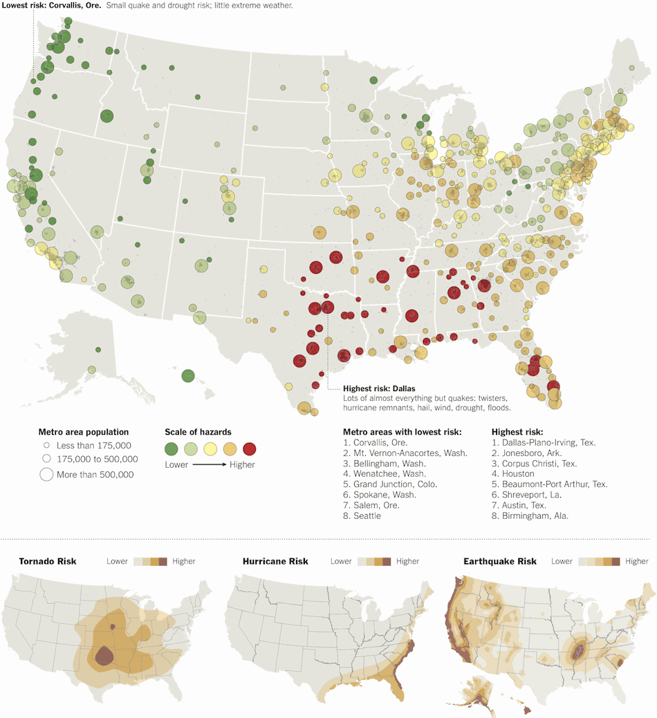
New York Times--Weather disasters and quakes: who’s most at risk? The analysis below, by Sperling’s Best Places, a publisher of city rankings, is an attempt to assess a combination of those risks in 379 American metro areas. Risks for twisters and hurricanes (including storms from hurricane remnants) are based on historical data showing where storms occurred. Earthquake risks are based on United States Geological Survey assessments and take into account the relative infrequency of quakes, compared with weather events and floods. Additional hazards included in this analysis: flooding, drought, hail and other extreme weather. Read More
Subscribe to:
Comments (Atom)